
Grant Opportunities

R.O. Anderson has dedicated staff to identify funding opportunities for public works projects. We realize that many public entities have neither the time nor resources necessary to fully research, monitor, and apply for federal, state, and local grant funding. R.O. Anderson analyzes grant/loan opportunities on a continual basis for a number of its clients and our team of professionals is available to help future clients find opportunities and develop the professional, convincing documentation necessary to generate competitive grant/loan requests. Additionally, once the funding is awarded, R.O. Anderson can assist with grant administrative services.
Our expertise in grant funding includes:
- Preparation of funding needs analysis designed to evaluate your organization’s current and future needs
- Grant research in order to maximize the funding for an upcoming project
- Support for grant proposal development
- Preparation of benefit-cost analysis to determine if the project’s benefits outweigh the costs
- Public participation and stakeholder outreach programs
- Preparation of an adequate and legally compliant environmental review
- Grant administration
Success Story
Caliente Youth Center Bridge Flood Mitigation Project
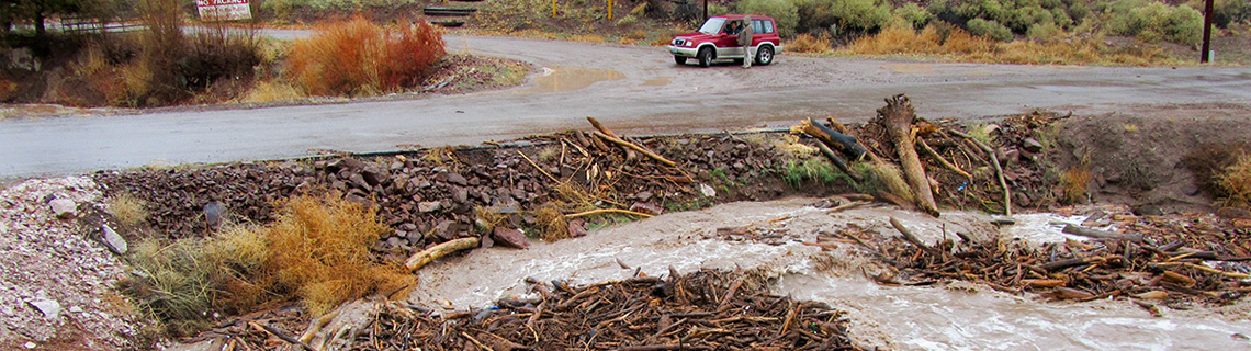
The Problem:
A flood event in January 2005 jeopardized the safety of residents and staff by preventing CYC relief staff and emergency vehicle access to the CYC facility for evacuation of residents and staff and by creating the potential for flooding of adjacent CYC structures. Flows emanating from the Clover Creek watershed exceeded culvert capacity and overtopped the roadway to a depth of three to five feet. Concern for the rising floodwaters resulted in an air evacuation of the residing children and CYC staff using Blackhawk helicopters dispatched from Nellis Air Force Base.
The Solution:
On behalf of the Nevada State Public Works Division, we prepared the preliminary engineering design, preliminary hydraulic analysis, benefit/cost analysis and detailed applications for submittal to Nevada Department of Emergency Management and FEMA for the Caliente Youth Center Bridge Flood Mitigation Project. Additionally, we coordinated with Federal, State and local project partners including Caliente Youth Center, Natural Resources Conservation Service, U.S. Fish and Wildlife Service, Lincoln County, City of Caliente, Lincoln County Power District #1 and secured both in-kind and monetary matches.
The Results:
The State Public Works Division was notified that the grant application was successful in the FEMA national competitive process. R.O. Anderson was also engaged to prepare the NEPA document for FEMA’s oversight on behalf of the State Public Works Board. This NEPA document has been approved and the project has now been funded for design and construction of the estimated $2,500,000 in flood mitigation improvements.